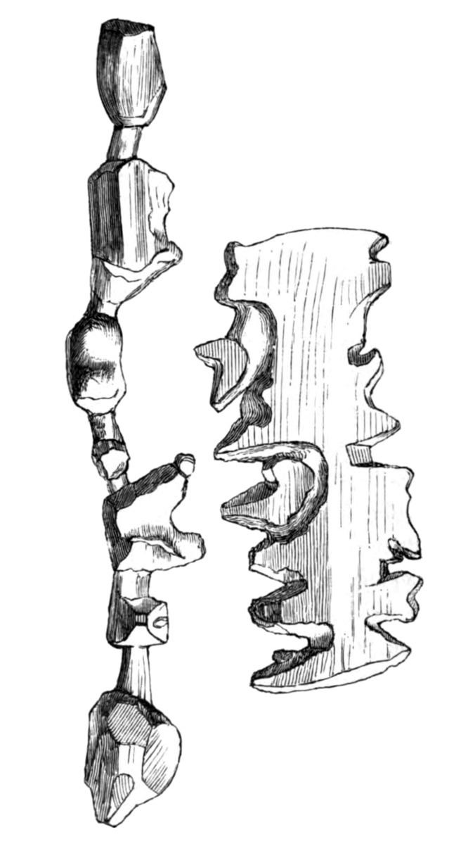
Ammassalik wooden maps are carved, tactile maps of the Greenlandic coastlines. In the 1880s, Gustav Holm led an expedition to the Ammassalik coast of eastern Greenland, where he met several Tunumiit, or Eastern Greenland Inuit communities, who had had no prior direct contact with Europeans. He returned to Denmark with a set of three-dimensional wooden maps of the coast around 66°N 36°W / 66; -36, carved by a native of Umivik named Kunit.
History
Kunit approached Holm on February 8, 1885, and sold the maps representing the coast from Sermiligak to Kangerdlugsuatsiak. Kunit returned on March 21 with another piece representing the peninsula between Sermiligak and Kangerdluarsikajik.
Upon Holm's return, the maps were deposited along with the rest of the collection at the National Museum of Denmark in Copenhagen. As of 1948 the maps were still in Copenhagen; copies were deposited in the Musée d'Ethnographie du Trocadéro in Paris. At some point the maps were transferred to the Greenland National Museum in Nuuk, which was established in the mid-1960s. Woodward & Lewis (1998) write that the "only other known example" of such a map is a specimen at the Michigan State University Museum — item 896.7, 62154 — which is probably a copy of Kunit's work.
In 2000, Post Greenland issued a stamp designed by Anne-Birthe Hove featuring the coastal map, as part of its "Greenland's Cultural Heritage" series. The Greenland National Museum loaned out the maps for a 2007-8 exhibition at the Field Museum of Natural History in Chicago entitled Maps: Finding Our Place in the World, which also traveled to the Walters Art Museum in Baltimore.
Features
Related maps
- Marshall Islands stick chart
- Straight-line diagram
Notes
References
- Hansen-Blangsted, Emile (19 February 1886), "Minutes", Comptes Rendus des Séances de la Société de Géographie et de la Commission Centrale (in French) (5), Société de Géographie: 162–163
- Hansen-Blangsted expresses doubt that the maps could have been carved by the natives. He mentions a talk he gave on 14 December 1885.
- Holm, Gustav (1886), "Eskimoiske 'Kaart' af Træ (Eskimo Wooden 'Charts')", Geografisk Tidsskrift (in Danish), 8: 103–105
- Holm quotes and rebuts Hansen-Blangsted (1886).
- Holm, Gustav; Garde, Vilhelm (1887), Den Danske Konebaads-Expedition til Grønlands Østkyst (The Danish Umiaq-Expedition to Greenland's east coast) (in Danish), Copenhagen: Thieles Bogtrykkeri, retrieved 9 November 2009
- Holm and Garde promise more scientific details in the forthcoming Holm (1888).
- Holm, Gustav (1888), "Den østgrønlandske Expedition, udført i Aarene 1883–85, Anden Del – Ethnologisk Skizze af Angmagsalikerne (The East Greenland Expedition, conducted in the years 1883–85, Second Part – Ethnological Sketch of the Ammassalik People)", Meddelelser om Grønland (in Danish), 10, Copenhagen: Blanco Lunos Kgl. Hof-Bogtrykkeri (F. Dreyer): 43–182
- Written in 1887, published in 1888. According to Elkins (1999, p. 225), this is the first publication of the maps.
- Amdrup, Georg Carl; Holm, Gustav Frederik; Thalbitzer, William (1914). The Ammassalik Eskimo : contributions to the ethnology of the East Greenland natives / by William Thalbitzer. doi:10.5962/bhl.title.27252.
- Mallery, Garrick (1893), "Picture-Writing of the American Indians", in Powell, J. W. (ed.), Tenth Annual Report of the Bureau of American Ethnology, 1888–89, Washington, D.C.: Government Printing Office
- This is largely a condensed translation of Holm (1888) into English. Mallery presents all three pieces in Fig. 455 on p.345, which is taken from Holm (1888, Table 41). Mallery's commentary on p.346 is from Holm (1888, p.144, Table 41).
- Thalbitzer, William (1914), Thalbitzer, William (ed.), "The Ammassalik Eskimo. Contributions to the Ethnology of the East Greenland Natives – Ethnographical collections from East Greenland (Angmagsalik and Nualik) made by G. Holm, G. Amdrup and J. Petersen and described by W. Thalbitzer", Meddelelser om Grønland, 39: 319–753
- Pages 1–147 in the same volume are an English translation of Holm (1888).
- Bagrow, Leo (1948), "Eskimo Maps", Imago Mundi, 5 (1): 92 two unpaged plates, doi:10.1080/03085694808591919
- Bagrow cites Holm 1888, Table 41 and some other sources. His photographs appear to be original.
- Sølver, Carl V. (May 1954), "Eskimoisk kartografi" (PDF), Grønland (in Danish) (5), Copenhagen: Det grønlandske Selskab: 187–192
- Sølver cites Holm (1914, p. 103), Thalbitzer (1914, p. 665), and Hansen-Blangsted (1886, p. 162). He includes original photographs of the pieces, and a traditional map of the area drawn by Thalbitzer in 1912 and published in Thalbitzer (1914). See also this issue's front matter.
- Sølver, Carl V. (Autumn 1957), "Eskimo Maps From Greenland", Archaeology, 10: 188–190
- This is an English translation of Sølver (1954) by a Mr. Christian Kampen of Copenhagen. Some parts are condensed or omitted. The article notes state that "Captain Sølver's article originally appeared in the Danish periodical Vikingen, in November 1954." Although it is possible that Sølver also published in the Norwegian satirical magazine Vikingen, this note is probably an error. Sølver's May 1954 article in Grønland is cited by other authors.
- MacEachren, Alan M. (1986), "A linear view of the world: Strip maps as a unique form of cartographic representation" (PDF), The American Cartographer, 13 (1): 7–25, CiteSeerX 10.1.1.140.8016, doi:10.1559/152304086783900185, archived from the original (PDF) on 2010-06-23, retrieved 2010-07-25
- MacEachren's citation and image source is Bagrow (1948).
- Woodward, David; Lewis, G. Malcolm, eds. (1998), Cartography in the Traditional African, American, Arctic, Australian, and Pacific Societies, The History of Cartography, vol. 2, University of Chicago Press, pp. 167–169, 176, ISBN 978-0-226-90728-4
- Woodward and Lewis cite Holm (1914, p. 107), Thalbitzer (1914, pp. 665–66), and Holm 1888, Table 41 (cited as "pl. XXXXL", a typo).
- Elkins, James (May 1999), The domain of images, Cornell University Press, pp. 225–228, ISBN 978-0-8014-3559-1
- Elkins cites (Holm 1888, p.101, p.144, Table 41) and Thalbitzer (1914, pp. 665–66). For photographs he references Leithäuser (1958) and Berthelsen et al. (1990).
- Buxton, Bill (2007), Sketching User Experiences: Getting the Design Right and the Right Design, Morgan Kaufmann, ISBN 978-0-12-374037-3
Further reading
- Leithäuser, Joachim G. (1958), Mappae Mundi, Die geistige Eroberung der Welt, Berlin: Safari-Verlag, p. 20
- Harvey, P. D. A. (1980), The history of topographical maps : symbols, pictures and surveys, London: Thames & Hudson, ISBN 978-0-500-24105-9
- Christian Berthelsen; Inger Holbech Mortensen; Ebbe Mortensen; W. Glyn Jones, eds. (1990), Kalaallit Nunaat Greenland Atlas, Copenhagen: Pilersuiffik, p. 1